East of Vík Attractions: What to See Toward Skaftafell
East of Vík Attractions: What to See Toward Skaftafell

East of Vík the Ring Road (Route 1) runs through lava fields, past a canyon and a small village, and on to Skaftafell in Vatnajökull National Park. The best stops are the mossy Eldhraun lava field, Fjaðrárgljúfur canyon, Kirkjubæjarklaustur and its waterfall, and Skaftafell with its trails to Svartifoss. Plan on a full day if you want to reach Skaftafell and walk there.
This guide covers each stop in the order you drive it, with what to expect, how much time to give it and where people get caught out.
TL;DR
- Skaftafell is the main destination east of Vík. It is about 130 km from Vík on Route 1, roughly 1.5 hours of driving without stops.
- On the way, the big stops are Eldhraun lava field, Fjaðrárgljúfur canyon and Kirkjubæjarklaustur. Together they fill a half day.
- Skaftafell has a year-round visitor center, flush toilets and trails from short walks to long treks. Ask the rangers about conditions before you set out.
- Starting from a bed near Vík saves you the long drive from Reykjavík and lets you reach the east side early in the day.
Table of Contents
- How the route east of Vík works
- Eldhraun lava field
- Fjaðrárgljúfur canyon
- Kirkjubæjarklaustur: the practical halfway stop
- Skaftafell: the main event east of Vík
- What about going farther east?
- Sample plans
- Our perspective on this stretch of road
- Where to stay for the drive east
- Practical tips for the drive
- FAQ
- Sources
How the route east of Vík works
There is one road, Route 1, and it is hard to get lost. What changes is the time of day you pass each stop and how long you linger. The eastbound drive is a sequence of stops spaced 20 to 60 minutes apart, with few services between them.
A sensible rhythm looks like this:
| Stop | What it is | Time to allow |
|---|---|---|
| Eldhraun | Moss-covered lava field beside the road | 20 to 30 minutes |
| Fjaðrárgljúfur | Winding canyon off Route 1 | 45 to 90 minutes |
| Kirkjubæjarklaustur | Village with a waterfall, café and fuel | 30 to 60 minutes |
| Skaftafell | National park area with trails and visitor center | 2 to 8 hours |
Drive times matter more than distances here. Fuel up in Vík or Kirkjubæjarklaustur, because stations are sparse once you pass the village. Before you leave, look at the south Iceland road conditions map from the Icelandic Road and Coastal Administration, especially between autumn and spring when ice and wind can change the plan.
For a deeper look at the same corridor, our guides to the waterfalls between Vík and Skaftafell and a day plan from Vík to Skaftafell go stop by stop.
Eldhraun lava field
Eldhraun is the first thing that makes you pull over. The lava flowed during the Laki eruption in the late 1700s, and it is now blanketed in thick, pale green moss. One regional guide puts the field at about 565 square kilometers and says the moss is fragile.
That fragility is the point to remember. Moss here grows slowly and takes years to recover from footprints. Stay on the pull-outs and marked paths, take your photos from the edge and do not walk onto it for a better angle. You do not need long here: a short stop, a few photos and you are back on the road.
Fjaðrárgljúfur canyon
Fjaðrárgljúfur is a winding, steep-walled canyon cut by a small river, signposted off Route 1 between Vík and Kirkjubæjarklaustur. It is a short detour from the highway, and it is one of the most photographed places on this stretch.
A few practical points:
- Respect closures. Protected areas in Iceland sometimes close to prevent erosion, especially in wet spring conditions. Check signs at the car park before you go in.
- Stay on the path. The canyon edge is soft and the drop is real. Stay behind barriers and keep children close.
- Leave the drone at home unless permitted. The Environment Agency of Iceland issues permits for flying in protected areas, and a 2024 permit notice lists Fjaðrárgljúfur among the protected sites involved. Without a permit, do not fly.
Give it an hour if the weather is good. In rain or strong wind, a shorter visit is fine, because the walls and the water are still impressive from the first viewpoint.
Kirkjubæjarklaustur: the practical halfway stop
Kirkjubæjarklaustur is a small village and the most useful pause between Vík and Skaftafell. Use it for fuel, a hot drink and a restroom, and walk to the nearby waterfall Systrafoss if you have the time. It is a calm place, and a good point to check the weather and road status for the next leg.
The national park says that Skaftafell is about 70 km from Kirkjubæjarklaustur, so this is your last real town before the park. Eat something here if you plan a long hike.
Skaftafell: the main event east of Vík
If you only have time for one thing east of Vík, make it Skaftafell. It sits within Vatnajökull National Park and is reachable along Route 1 all year. According to the park’s own page, it has flush toilets and a year-round visitor center, Skaftafellsstofa, and trails ranging from easy half-hour walks to treks of around 10 hours.
Svartifoss and the classic loop
Svartifoss is the waterfall framed by dark basalt columns, and it is the highlight most visitors come for. The Svartifoss, Sjónarsker and Sel route is 5.8 km and combines the waterfall with a viewpoint and the old turf-roofed farm buildings at Sel. Allow a few hours at a relaxed pace, longer with photo stops.

Longer routes
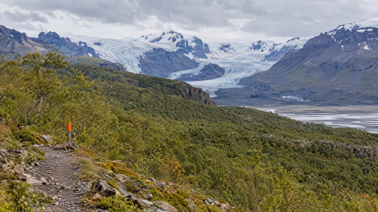
The challenging walk around Skaftafellsheiði takes you through birch forest and uplands, with the Morsárjökull and Skaftafellsjökull glaciers on either side. It is a serious day out, not a casual stroll. Our guide to Skaftafell hikes by length sorts routes from one to eight hours.
Check conditions first
The park’s rangers say success here depends on fitness and preparation, and they recommend asking at the visitor center for local conditions before you start. Steps and platforms can turn treacherous when wet or frozen. The Skaftafellsheiði trail is often impassable in spring because of wet mud, and the park notes it can stay closed until mid-June to prevent erosion. Read the trail status boards at the visitor center rather than relying on a map printed last year.
For general preparation, the national rescue association’s hiking and trekking guidance tells you to assess your experience, fitness and equipment honestly. Its outdoors page is blunt about weather: cold, wind and rain together can be dangerous without proper clothing.
Glaciers: go with a guide
Glacier ice is not a place to improvise. Safetravel’s glacier and crevasse guidance warns that Icelandic glaciers move constantly and that conditions on them can be harsher than elsewhere. If you want to stand on ice, book a licensed guided tour rather than walking onto a glacier on your own.
What about going farther east?
Beyond Skaftafell the road continues toward Jökulsárlón, Diamond Beach and Höfn. The national park puts Skaftafell about 130 km from Höfn. Those places are real highlights, but from Vík they make for a very long day out and back.
If you want to see them, split the trip. Spend one night near Vík, drive east the next morning, and decide on the way how far to go. Our 2-day South Coast itinerary is built to avoid long stretches of 8 to 9 hours of driving in a day.
Sample plans
Half day: lava, canyon and a village
Leave mid-morning, stop at Eldhraun, visit Fjaðrárgljúfur, have lunch in Kirkjubæjarklaustur and be back for dinner. It is relaxed and works well in short winter daylight.
Full day: Skaftafell as the goal
Leave early. Do the three stops above briskly, arrive at Skaftafell by late morning, walk the Svartifoss route, then head back before dark. This is the plan most travelers use, and the one that makes the most of a base near Vík.
Two days: slow it down
Day one covers the half-day plan and a longer evening. Day two goes to Skaftafell for a longer trail, or farther east if the weather is good. Our 2 to 3 day Vík itinerary helps you decide where the west side of Vík fits in.
Our perspective on this stretch of road
We are a hostel in a converted barn near Vík, and we talk to travelers about this drive every day. The most common mistake is trying to do too much. People set off for Jökulsárlón, stop at everything on the way and reach Skaftafell tired, in poor light and with no time to walk.

Our advice is simple. Choose one anchor, usually Skaftafell, and let the other stops be short. Start early, eat a proper breakfast before you go and carry layers even in summer. Ask the rangers about the trails, not the internet. And when the wind is up or the road is icy, change the plan without feeling you have failed. The landscape will still be there tomorrow.
The other thing we learned is that the evening matters as much as the day. After hours of driving and hiking, it helps to come back to a warm kitchen, a table of other travelers swapping tips, and a pizza that does not require another drive.
— Siggi
Where to stay for the drive east
If you are planning this route, a base close to Vík cuts a lot of driving from the day. At Fox Hostel you can book shared or private dormitories in our renovated barn, with a communal kitchen, breakfast and Hrífunes Pizzeria on site for dinner. Traveling with friends, a club or a tour group? You can reserve rooms for your group. If you want something active on a rest day, we also offer a rafting adventure with a partner.
We do not publish room prices in this article, so check the booking page for what is available on your dates.
Practical tips for the drive
- Weather and roads. Read the Icelandic Road and Coastal Administration’s guidance on driving in Iceland before you pick up a rental car, and check the road map each morning in the colder months.
- Daylight. In winter the usable daylight is short. Do fewer stops and start at first light.
- Food and fuel. Fill your tank in Vík or Kirkjubæjarklaustur. Bring snacks and water for Skaftafell trails.
- Footwear. Waterproof hiking boots, not sneakers, if you plan to walk the Skaftafell trails.
- Leave no trace. Keep to paths on moss and in protected areas. Pack out everything you bring.
For more nearby ideas on the west side of the same base, see must-see attractions near Vík and our guide to scenic spots near Vík.
FAQ
What is the best thing to see east of Vík?
Skaftafell in Vatnajökull National Park is the strongest choice. It has marked trails, a visitor center and the Svartifoss waterfall. Eldhraun and Fjaðrárgljúfur are good shorter stops on the way.
How far is Skaftafell from Vík?
About 130 km on Route 1, or roughly 1.5 hours of driving without stops, according to one South Coast itinerary. Add time for stops, weather and photos, and plan a full day for the round trip.
Can I walk Skaftafell trails in any season?
The area is accessible year-round along Route 1, but trail conditions vary. Some routes, such as Skaftafellsheiði, can be closed in spring until mid-June. Ask at Skaftafellsstofa visitor center before you set out.
Is it safe to walk on a glacier by myself?
No. Icelandic glaciers move and have crevasses, and Safetravel advises caution on them. Join a licensed guided tour if you want to go onto the ice.
Sources
- Skaftafell, Vatnajökull National Park
- Svartifoss, Sjónarsker, Sel, Vatnajökull National Park
- Skaftafellsheiði, Vatnajökull National Park
- Outdoors in Iceland, Safetravel
- Hiking and trekking, Safetravel
- Glacier safety and crevasse maps, Safetravel
- Drone permit notice, Environment Agency of Iceland
- Eldhraun Lava Field, Iceland Travel
- Iceland South Coast 3-Day Itinerary, Isnet