Vík to Dyrhólaey Day Trip: Plan, Timing and Safety
Vík to Dyrhólaey Day Trip: Plan, Timing and Safety

Dyrhólaey is a short drive west of Vík, so this is one of the easiest and most rewarding half-day outings on Iceland’s South Coast. Plan on two to four hours at the cape itself, start with the lower Lágey area for birds and beach, then drive up to Háey for the arch and the long coastline views. Check the weather and the nesting-season access rules first, because both can change your route on the day.
Below is how we would do it, hour by hour, with the rules that actually matter and the mistakes we see visitors make. We run Fox Hostel near Vík, so this is the stretch of road we know best.
TL;DR
- Give Dyrhólaey at least 1 to 2 hours, and more if you want both the lower Lágey level and the upper Háey level.
- Puffins nest here from May through September. The Environment Agency of Iceland points visitors to the sea cliffs near the Lágey parking area, and asks everyone to stay on marked trails.
- Parts of Dyrhólaey can be closed from May 1 to June 25 for nesting birds, so check before you set out.
- Pair Dyrhólaey with Reynisfjara, but treat the sea there as dangerous even when it looks calm.
- Check road.is for wind and road conditions right before you leave, not the night before.
Table of Contents
- What a Vík to Dyrhólaey day trip looks like
- Lágey and Háey: two levels, two experiences
- Timing: seasons, closures and puffins
- How much time to spend at Dyrhólaey
- Pair it with Reynisfjara, and respect the sea
- Before you drive: weather, roads and drones
- Coming from Reykjavík: is a same-day round trip worth it?
- Our perspective: make Vík the base, not the stop
- Stay near the cape: Fox Hostel
- FAQ
- Sources
What a Vík to Dyrhólaey day trip looks like
The geography does most of the planning for you. Vík sits on the Ring Road, and Dyrhólaey is a short detour off it along a side road. The cape is a protected nature reserve: a 120 m high tuya formed in at least two eruptions around 100,000 years ago, protected since 1978 for its scenery and its birdlife.
That short distance is the good news. It means you do not need a rushed schedule. A realistic loop from Vík looks like this:
- Morning: breakfast in Vík, check conditions, drive to Dyrhólaey.
- Late morning: Lágey for the paths, the birds and the black sand beach below the cape.
- Midday: Háey for the arch and the lighthouse viewpoints.
- Afternoon: Reynisfjara and its basalt columns, from the designated viewpoint if the warning level says so.
- Evening: a proper meal and a bed, not a drive back to Reykjavík.
That last point deserves its own section, because it changes the whole trip. We come back to it below.
Lágey and Háey: two levels, two experiences
Most first-time visitors head straight for the lighthouse at the top. It is a fine view, but it is only half of the cape.
Lágey, the lower level
Lágey is the lower area, ideal for birdwatching. It sits east of the arch and gives access to the black sand beach, Kirkjufjara. The Environment Agency of Iceland says puffins can often be seen parading in front of their burrows in the sea cliffs by Arnardrangur, or flying around the Háey cliffs. In practice, the paths that start from the Lágey parking area give calmer, closer and more sheltered birdwatching than the exposed summit.

Our own guide to this walk, seeing puffins near Vík on a self-guided 15 to 20 minute plan, covers the route in detail. For the season as a whole, see what travelers need to know about puffins in Iceland.
Háey, the upper level
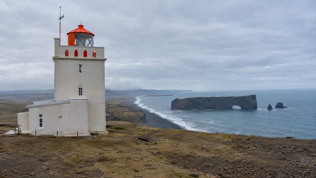
Háey is the upper plateau, where the lighthouse stands and where you get the panoramic coastline and the classic view of the rock arch. If you are short on time, this is the stop for photographs. If you want the full detail on trails and timings, we wrote up the Dyrhólaey lighthouse walk with routes, times and closures.
Wind on top
Visitors regularly underestimate the wind. Even on a sunny day, gusts on the cliff top can make the exposed paths hard to walk, and dangerous near the edges, as the access and management guidance from the Environment Agency of Iceland makes clear. Keep well back from edges, hold on to hats, phones and car doors, and turn around if it feels wrong. A view is never worth a fall.
Timing: seasons, closures and puffins
| Period | What to expect at Dyrhólaey |
|---|---|
| May 1 to June 25 | Possible access restrictions to protect nesting birds |
| May to September | Puffin nesting season, best chance of seeing them at the cliffs |
| Outside nesting season | Fewer birds, but drone and path rules still apply |
The closure window comes from the Environment Agency of Iceland, and the key detail is that it is not fixed. According to the agency, the decision to close the area is made annually by an ornithologist, based on the state of the local bird populations. That means a blog post from 2019 cannot tell you whether the upper area is open this year. Check the official page the week you travel, and read the signs on arrival.
If you visit in the nesting window and the upper paths are restricted, you have not lost the trip. The Lágey and Háey viewing areas have in past seasons stayed accessible while the arch-top paths were closed, according to a traveler discussion that is worth reading as background, though the agency’s page is the one to trust for the current year.
For the best of the puffin season, aim for late spring through summer. They are a seasonal draw, so if puffins are the reason for your trip, build the whole itinerary around the months from May to September.
How much time to spend at Dyrhólaey
The agency suggests at least one to two hours to see both levels. Here is how we would split it, depending on what you want:
- Quick stop, about 45 minutes: Háey only. Arch, lighthouse, photos.
- Standard visit, 1.5 to 2 hours: Lágey first for birds and the beach, then Háey.
- Unhurried visit, 3 to 4 hours: Both levels, a slow walk along the paths, a sit-down with a thermos, and time for the light to change. Dyrhólaey in low evening light is a different place.
If you keep the day flexible, you can let the weather choose. Clear and breezy mornings suit the cliffs. Misty and still hours suit birdwatching from the lower paths.
Pair it with Reynisfjara, and respect the sea
The black sand beach of Reynisfjara is the natural companion to Dyrhólaey, and a combined Vík day almost always includes both. It is also where the day’s real danger sits.
Safetravel.is classes Reynisfjara as a high-hazard location because of sneaker waves: powerful, unpredictable surges that can arrive without warning. Local officials use a color-coded warning system:
- Yellow: moderate hazard.
- Orange: considerable hazard, stay at least 25 meters from the sea.
- Red: severe hazard, beach closed to foot traffic. Stay at the designated viewpoint.
Fatalities have occurred here, and the guidance is blunt: never turn your back on the sea. The part that surprises people is that a calm sea is no reassurance. Sneaker waves tend to come after long stretches of small waves, so what the water looks like right now tells you nothing about the next minute.
Our own pieces go deeper: why to stay 20 to 30 meters back at Reynisfjara and what to do before you park, including saving 112. Read one before you go, especially if you are traveling with children or a group. Keep photographs for the viewpoint, and keep your distance from the waterline on any warning level.
Before you drive: weather, roads and drones
Check road.is the same morning
Weather in Vík is not weather on the whole South Coast. Conditions can shift fast, and local alerts about wind or ice can change within minutes. The road.is traffic and conditions site links to live road and sea condition information. Look at South Iceland specifically, immediately before departing. An Icelandic tourism perspective we like is to keep the plan flexible and expect the weather to change every few minutes, as the Visit Reykjavík local guide puts it.
Pack for wind, not for temperature
A windproof shell, a hat that stays on, sturdy shoes with grip and something warm to drink matter more than a heavy coat. Trails can be wet and uneven, and the hiking guidance on Safetravel is a good checklist for assessing your experience, fitness and equipment before any walk.
Drones: mostly not here
If you are planning aerial footage, know the rules. The Environment Agency’s guidelines set a 200-meter prohibited zone from bird cliffs during the nesting season from May to September, and 50 meters outside that period when birds are present. Commercial drone use also requires prior registration with the Icelandic Transport Authority. For most visitors the simplest answer is to leave the drone in the bag.
Coming from Reykjavík: is a same-day round trip worth it?
It can be done. Reykjavík to Vík is roughly a two-hour drive each way according to the sources Google surfaces for this search, and plenty of travelers squeeze in two waterfalls, Reynisfjara and Dyrhólaey in one long day. We would not. You end up spending most of your light behind the wheel, and Dyrhólaey, the one stop that rewards slow time, becomes the one you hurry.
Our Reykjavík to Vík drive guide covers distances, times and the best stops on the way. If you want the whole coast in a sensible rhythm, our two-day South Coast itinerary shows how to avoid 8 to 9 hours of driving in a single day, and how to plan a South Coast itinerary in Iceland helps you build your own.
The better version of this day starts in Vík, not Reykjavík. Sleep near the cape, and Dyrhólaey is a ten-minute decision rather than a three-hour commitment. If you also want a full list of spots around town, see how to discover scenic spots near Vík.
Our perspective: make Vík the base, not the stop
We are a converted Icelandic barn in the South Iceland countryside, and we have watched the same pattern for years. Guests who arrive on a tight day trip look slightly stressed at 4 p.m. Guests who stay the night look relaxed at 4 p.m., because they have already done the cliffs in the morning and are deciding whether to do the beach again in the evening light.

Our view is simple. Dyrhólaey is small enough to do in a morning, and good enough to deserve one. Go to Lágey first, while the birds are active and the paths are quieter. Save Háey for when the wind drops or the light improves. Keep Reynisfjara for a moment when you can be calm, careful and unhurried. And do not plan so tightly that a gust, a closure or a fog bank ruins the day.
What we like about staying out here is the rhythm: breakfast at the hostel, a day among landscapes, then a hot meal at Hrífunes Pizzeria on site, without another drive. The shared spaces make it easy to compare notes with other travelers, which is usually how people hear which path is open and which beach has a red light that day. For a longer picture, our 2 to 3 day plan for Vík shows how we would spread it out.
— Siggi
Stay near the cape: Fox Hostel
If you want to do Dyrhólaey at your own pace, book a bed or a room at Fox Hostel. We offer shared and private dormitories in our renovated barn near Vík, breakfast at the hostel and pizza at Hrífunes Pizzeria in the evening. Traveling with friends or a club? You can reserve rooms for your group through our group bookings page. And if you want something wetter than a cliff walk, we also offer a rafting adventure from the same base.
New to hostels? Our honest guide to dormitory rooms explains what to expect.
FAQ
How much time should I spend at Dyrhólaey?
Plan for at least one to two hours if you want to see both the lower Lágey level and the upper Háey level, according to the Environment Agency of Iceland. A quick visit to the lighthouse viewpoint alone takes much less. Photographers and birdwatchers will happily use three to four hours.
Is Dyrhólaey worth it?
Yes, especially if you are already in Vík. You get a protected nature reserve, a famous rock arch, wide coastal views and, in season, puffins, all a short drive from town. It is also easy to combine with Reynisfjara in the same outing.
What time of year can I see puffins at Dyrhólaey?
The nesting season runs from May through September. The most reliable spots are the sea cliffs near the Lágey parking area, and you should stay on marked trails to protect the burrows. Note that some areas may be closed from May 1 to June 25, depending on a yearly decision by an ornithologist.
Can I do Reykjavík to Vík and Dyrhólaey in one day?
You can, but it is a long day with most of the time spent driving. If Dyrhólaey and Reynisfjara are your priorities, an overnight stay in Vík gives you far more time at both and less pressure on the road home.
Is Reynisfjara safe to visit on the same day?
It can be, if you respect the warning levels. Sneaker waves can occur without warning, even when the sea looks calm. On orange, stay at least 25 meters from the water, and on red, stay at the viewpoint and never turn your back on the sea.
Sources
- Umhverfisstofnun: Dyrhólaey
- Umhverfisstofnun: Access and management
- Umhverfisstofnun: Research and education
- Umhverfisstofnun: Guidelines for using drones in protected areas
- Safetravel: Black Beach Safety
- Safetravel: Hiking / Trekking
- Road.is: Traffic Info
- Visit Reykjavík: Explore Reykjavik like a local
- Tripadvisor Iceland Forum: Dyrhólaey closed?