Vík to Kirkjubæjarklaustur: The Best Stops Along the Way
Vík to Kirkjubæjarklaustur: The Best Stops Along the Way

The drive from Vík to Kirkjubæjarklaustur takes about two hours without stopping, but with the stops worth making it becomes a full day, according to Visit South Iceland’s guide to the geosites along the Ring Road. In that time you cross a black sand plain, the world’s largest moss-covered lava field, a mountain that was once an island, a deep green canyon and a village built around basalt columns. This guide puts the stops in driving order, tells you how long each deserves, and flags the places where the weather or the waves can turn a good day bad.
TL;DR
- Vík to Kirkjubæjarklaustur is about a two-hour drive on Route 1, and a full day once you add stops.
- The must-stops in order: Hjörleifshöfði, Laufskálavarða, Eldhraun lava field, Fjaðrárgljúfur canyon, then Kirkjubæjarklaustur itself (Systrafoss, Kirkjugólf, Dverghamrar).
- Lómagnúpur, the huge mountain just east of town, is a good turnaround landmark if you want to push on.
- Check road and weather conditions on Safetravel before you leave, and treat the Reynisfjara wave warnings as non-negotiable if you start the day on the beach.
- Sleeping near Vík and driving east in the morning gives you the whole day with the light on your side.
Table of Contents
- How the day works: direction, timing and planning
- Before you leave Vík: Reynisfjara and Dyrhólaey
- Stop 1: Hjörleifshöfði
- Stop 2: Laufskálavarða
- Stop 3: Eldhraun lava field
- Stop 4: Fjaðrárgljúfur canyon
- Stop 5: Kirkjubæjarklaustur and its surroundings
- Driving the road safely
- What we would do: a sample day
- Perspective: why we base ourselves here
- Stay near Vík and make the day easier
- FAQ
- Sources
How the day works: direction, timing and planning
Most travelers drive this stretch from west to east, leaving Vík in the morning and finishing at Kirkjubæjarklaustur (locals just say “Klaustur”) in the afternoon. That order puts the long, open sand plain early, when you are fresh, and leaves the walkable, leafy Klaustur area for the end of the day when you want a coffee and a short stroll rather than a drive.
The South Coast route is open year-round, and its main roads are regularly serviced and generally easy to drive in both summer and winter, according to Visit South Iceland. That does not mean conditions never change. Wind, ice and sudden storms are the norm in the shoulder seasons and winter, so look at the official conditions before you set off. We wrote a daylight-first winter safety checklist for exactly that reason.
A realistic budget for the day looks like this:
| Stop | Typical time | Effort |
|---|---|---|
| Reynisfjara or Dyrhólaey (optional, before you leave Vík) | 45 to 90 minutes | Easy, with wave caution |
| Hjörleifshöfði | 45 to 90 minutes | Short trail to the top |
| Laufskálavarða | 10 to 15 minutes | Roadside |
| Eldhraun | 15 to 30 minutes | Roadside pullouts |
| Fjaðrárgljúfur | 1 to 2 hours | Easy walk along the rim |
| Kirkjubæjarklaustur (Systrafoss, Kirkjugólf, Dverghamrar) | 1 to 2 hours | Short walks |
These durations are our own working estimates from how guests usually spend their days, not official figures. Add time for photos, coffee and weather.
Before you leave Vík: Reynisfjara and Dyrhólaey
Technically these sit west of Vík, so they are a detour rather than part of the road to Klaustur. Still, many guests do them first thing, and they deserve a plan.
Reynisfjara black sand beach
The beach has a color-coded, automated wave-warning system, and Iceland Highlights notes that visitors should strictly avoid the waterline because sneaker waves arrive without warning and can be fatal. Read the light before you walk down: if it is yellow or red, stay well back. Our own notes on staying 20 to 30 meters back from sneaker waves and what to do before you even park are worth reading the night before.
Dyrhólaey
The headland is a good puffin-viewing spot. Puffin season runs from mid-April to mid-August, and according to this local guide the area is closed at night from 19:00 to 09:00 between May 1 and June 25, with the upper road closed outside those hours. Our self-guided puffin plan for Dyrhólaey fits into 15 to 20 minutes, and the July puffin season overview covers what to expect later in summer.
Stop 1: Hjörleifshöfði
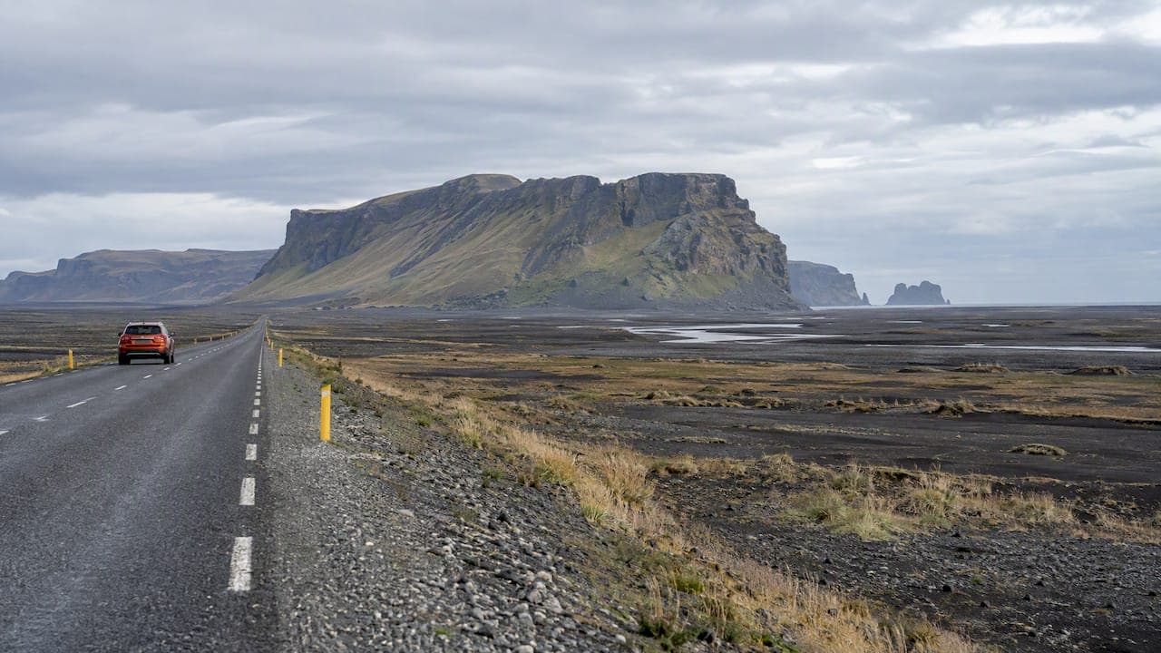
Heading east out of Vík, the road crosses Mýrdalssandur, a wide black outwash plain. Hjörleifshöfði rises out of it like a ship. It is a tuya, a flat-topped mountain formed under ice, and it holds a place in the settlement story of Iceland. The Visit South Iceland geosite guide lists it among the area’s historic and cultural sites and notes that it has a small car park and a trail to its top.
Two practical points. The car park is small, so in high season you may wait or park carefully. And the plain is exposed: on a windy day, sand and gusts hit hard, so hold your car doors with both hands. If the weather is rough, enjoy the view from the road and save the climb.
Stop 2: Laufskálavarða
A short drive further east you will see a low ridge crowded with small cairns. Laufskálavarða is a lava ridge covered with hundreds of small piles of rocks, and it is among the cultural stops the official geosite guide names on this route. Travelers have long built a cairn here for luck on the journey ahead. You can add a stone of your own in ten minutes.

Keep to the existing path and do not disturb other people’s cairns. It is a small stop, and it makes a good moment to stretch your legs and check the sky.
Stop 3: Eldhraun lava field
This is the stretch of road where passengers suddenly stop talking. Eldhraun, “fire lava,” is described by Iceland Unlimited as the world’s largest lava field from a single eruption, covering 565 square kilometers between Vík and Kirkjubæjarklaustur and created in the Laki eruption of 1783 to 1784. Centuries of woolly fringe moss now cover it in pale green.
The rule here is simple: stay on the paths and in the pullouts. The moss takes decades to grow and does not recover quickly from being walked on, which is why photographers who step off the path leave scars that last for years. Take your photo from the edge, and do not lie down on it.
Stop 4: Fjaðrárgljúfur canyon
This is the highlight for most people, and it is close to Klaustur. The canyon has beautiful palagonite formations, and visitors can walk along its edge and look down from above, as the official geosite guide describes.
A few things to know before you go:
- Allow one to two hours. The walk along the rim is easy, and the views change at every viewing platform.
- Stay behind the barriers. The canyon has been restricted before because so many visitors left the marked paths and damaged the fragile vegetation, and it can be temporarily closed in spring and autumn when the trails are soft and muddy. Check the current status before you drive out.
- Mind the drones. The same source says a permit is required in this protected nature reserve.
- Bring waterproofs and real shoes. Even in summer the path can be wet.
If you arrive and the canyon is closed, do not hop the fence. The rest of the day is full of alternatives.
Stop 5: Kirkjubæjarklaustur and its surroundings
Klaustur is small, but it packs a lot into a short walk. Visit South Iceland lists the village’s services: a swimming pool, a campground and gas stations. That makes it the natural place to refuel, in every sense, before the next leg.
Systrafoss
The waterfall drops down the hillside behind the village and is one of the most easily accessed sights. It is a quick walk from the center, so this is an easy add-on if you are tired from driving.
Kirkjugólf
The name means “church floor.” It is a flat pavement of basalt columns, seen from above like a tiled floor, and it is one of the geological formations in the official list for the area. It is a ten-minute stop and good for families.
Dverghamrar
The “dwarf cliffs” are another set of basalt columns. They are quiet and easy to reach, and they work well if the main crowd is at Fjaðrárgljúfur.
Lómagnúpur
This massive mountain stands just east of Klaustur, and the geosite guide lists it among the area’s formations. You can see it clearly from Route 1 without leaving the car. If you plan to continue to the glacier lagoons, it is your signal that you are entering a new stretch of the coast.
For more local detail we have written a longer tourist guide to Kirkjubæjarklaustur, and our nearby nature stops guide is available in Italian. We also have a road trip guide between Vík and Klaustur, also in Italian, if someone in your group prefers it.
Driving the road safely
The route itself is easy. The risks come from small things that surprise visitors from other countries.
- Single-lane bridges. Iceland has many, on and off the Ring Road. The vehicle closer to the bridge has right of way, so slow down and assess the situation before you cross.
- Conditions. Safetravel publishes travel conditions and has an app with the latest information and alerts, which is the place to check each morning.
- Wind and sand. The plain east of Vík is open and exposed. Park facing into the wind where you can.
- Fuel. Klaustur has gas stations, so treat it as your planned refill rather than waiting for the needle.
- Pullouts. Use designated pullouts, not the road shoulder, to stop for photos. It protects you and the moss.
If you are also visiting the beaches, our post on checking Safetravel lights at the black sand beaches and our waterfall exploration tips are good companions to this guide.
What we would do: a sample day
- Breakfast at the hostel. Start early, with a proper breakfast.
- Hjörleifshöfði in the morning, while the car park is quiet.
- Laufskálavarða and Eldhraun on the way east, with short stops only.
- Fjaðrárgljúfur around midday, if the canyon is open.
- Klaustur for lunch, fuel and a walk to Systrafoss and Kirkjugólf.
- Drive back west with the light behind you, and a pizza waiting.
This is a long day, and it is better to do it as a loop from a base near Vík than to move your bags every night. That is also why we built the hostel where it is.
Perspective: why we base ourselves here
We run Fox Hostel in a renovated barn in the South Iceland countryside near Vík, and the question we hear most from guests is whether to split this drive into two nights. Our honest answer: for most people, one base and one full day is enough. You see the best of the stretch, you are not repacking, and you still have the evening to eat and talk with other travelers in the common areas.

What we see again and again is that the guests who enjoy this route most are the ones who start earlier and stop less often than they planned. Pick four stops, not nine. Spend real time at Fjaðrárgljúfur and in Klaustur, and enjoy the stretches in between from the car window. The moss, the sand plain and the mountains are part of the experience, not just the gaps between sights.
And please respect the safety signs. In our experience, the day goes wrong not because of the road, but because someone ignored a wave warning or a closed path.
— Siggi
Stay near Vík and make the day easier
If you want a base for this drive, we offer shared and private dormitories in our converted barn, with a communal kitchen, breakfast, and Hrífunes Pizzeria on site for dinner when you return. Traveling with friends or a club? You can reserve rooms for your group. If you want to add something active on another day, we also offer a rafting adventure through partners. For our current rates and availability, please check the booking pages, as we do not publish fixed prices here.
FAQ
How long does it take to drive from Vík to Kirkjubæjarklaustur?
About two hours without stops, according to Visit South Iceland. With the stops listed here, plan a full day. If you are short on time, choose Hjörleifshöfði, Eldhraun and Fjaðrárgljúfur.
Is the road open in winter?
The South Coast route is accessible year-round and its main roads are regularly serviced, as Visit South Iceland states. Conditions can still change quickly with wind or ice, so check Safetravel in the morning and leave extra time. Daylight is short in winter, so start early.
Where can I get fuel and food along the way?
Kirkjubæjarklaustur has gas stations, a swimming pool and a campground, as noted in the official geosite guide. There is very little between Vík and Klaustur, so fill up before you leave and bring snacks and water.
Which stop is the most worth the time?
For most travelers it is Fjaðrárgljúfur, because you can walk along the canyon edge and see its formations from above. Eldhraun is the best stop for little effort. If the canyon is closed, spend the time in Klaustur instead.
Sources
- Geosites near the Ring road, East side, Visit South Iceland
- The South Coast, Visit South Iceland
- How to Drive in Iceland, Safetravel
- Reynisfjara Black Sand Beach, Iceland Highlights
- Puffins in Vík: Best Spots and When to See Them
- Eldhraun Lava Field, Iceland Unlimited
- Fjaðrárgljúfur Canyon Iceland: Trail Length, Difficulty and Parking Fee